
Wednesday, September 30, 2009
Simple Pleasures
Today's Washington Post includes a review of Simple Pleasures Ice Cafe in Bowie. I knew it was only a matter of time before the Washington Post started stealing story ideas from Bowie Living (see post here).
Monday, September 28, 2009
Security Failure
On Sunday, we attended the Old Town Bowie Antique & Craft Festival. On the way back to the car, we walked by this car parked in the road. It reminded me of some of the pictures that you see on the Fail Blog.

The festival was smaller this year. The roads were open to cars near the Old Bowie Town Grille, and there were only a couple of vendors on that side of the train tracks.

The other failure was my failure to notice the owner of this car walking up behind me while I was taking the picture!
The festival was smaller this year. The roads were open to cars near the Old Bowie Town Grille, and there were only a couple of vendors on that side of the train tracks.
Wednesday, September 23, 2009
Can You Draw U.S. Map from Memory?
OK. I admit it. I have a man crush on Al Franken. Do you think Norm Coleman can do this?
National Harbor and the Woodrow Wilson Bridge Trail
We took a trip to National Harbor to walk the recently opened trail that runs along the Potomac River, crosses the Capital Beltway, and continues to Virginia over the Woodrow Wilson Memorial Bridge.

 Here is a closer look at the waterfront. The right hand from The Awakening is visible on the mini beach.
 Here is some of the artwork along the stairs leading down toward the water.
 A closer look at The Awakening.
 What good is art if you can't climb on it?
 A view of National Harbor from one of the two piers.
 A sneaker floats in the water nearby. Luckily, it's not attached to a body.
 The start of the paved trail. The part of the trail that is on the National Harbor property is made of crushed shells. It's not great for bike riding, and many people find National Harbor to be unfriendly to bike riders (see this article and blog post from last summer). Both of those stories mention lack of parking for bicycles in National Harbor, and the presence of a security guard that asks bicyclist to dismount as they enter the National Harbor property. During our trip, there was a new bike rack at the end of the trail in National Harbor, and no security guard was present. There was a sign instructing bike riders to dismount.
 Here is the view from the trail as it winds close to the Capital Beltway. The bridge seen in the top-center of the picture is part of the trail.
 A view of National Harbor from the trail.
 I had heard that people spotted eagles near the Wilson Bridge. We did see one flying very high in the sky over the water between National Harbor and the Wilson Bridge. I really had to search the sky to see it, and when I did see it without the camera, I wasn't completely sure that it was an eagle.
 A view from the trail near the bridge over the Capital Beltway. The trail slopes up toward the bridge - no stairs.
 On the bridge.
 Here is Sergeant Gregg from the Maryland Natonal Park Police riding a motorized scooter. The trail is patroled every day from 5:00am to midnight.
 You can take segway tours from National Harbor. The woman in the front is guiding the tour. Notice how she's looking back over her shoulder instead of watching where she's driving? She nearly ran into my son, but she never knew. The guy on the left is driving around a blind corner in the wrong lane while checking out the views to the right.
 Looking toward Virginia from the trail bridge.
 Ramp leading from the trail bridge to the North side of the Wilson Bridge. The people in the picture told us that they saw wild turkeys near the trees on the right.
 We saw a single Maryland State Trooper pull over 5 or 6 cars leaving Maryland on the inner loop. Beware of the speed trap!
 A view of the George Washington Masonic National Memorial from the Wilson Bridge.
 A view of the Washington Monument from the Wilson Bridge. It's not leaning. I must have been.
 Another view from the Wilson Bridge. The National Cathedral can be seen on the top-left. A plane lands at National Airport in the center of the picture.

The street slopes down toward the Potomac River. The new Wilson Bridge is in the background.
 Here is a closer look at the waterfront. The right hand from The Awakening is visible on the mini beach.
 Here is some of the artwork along the stairs leading down toward the water.
 A closer look at The Awakening.
 What good is art if you can't climb on it?
 A view of National Harbor from one of the two piers.
 A sneaker floats in the water nearby. Luckily, it's not attached to a body.
 The start of the paved trail. The part of the trail that is on the National Harbor property is made of crushed shells. It's not great for bike riding, and many people find National Harbor to be unfriendly to bike riders (see this article and blog post from last summer). Both of those stories mention lack of parking for bicycles in National Harbor, and the presence of a security guard that asks bicyclist to dismount as they enter the National Harbor property. During our trip, there was a new bike rack at the end of the trail in National Harbor, and no security guard was present. There was a sign instructing bike riders to dismount.
 Here is the view from the trail as it winds close to the Capital Beltway. The bridge seen in the top-center of the picture is part of the trail.
 A view of National Harbor from the trail.
 I had heard that people spotted eagles near the Wilson Bridge. We did see one flying very high in the sky over the water between National Harbor and the Wilson Bridge. I really had to search the sky to see it, and when I did see it without the camera, I wasn't completely sure that it was an eagle.
One day I hope to get a "big boy" camera, but right now I am using a Canon PowerShot SX10IS. One of the features that I like most is the 20x optical zoom. I took maybe 40 pictures of the eagle, and I copy/pasted the five best into the collage above. Even with the 20x zoom, the images are still blurry, but they're clear enough to make out that this is an eagle. I did see some people on the trail with fancy photography equipment, and I developed a case of lens envy.
At one point, a sea gull flew close to the eagle, and I thought that maybe we would witness a kill. It was not to be.
 A view from the trail near the bridge over the Capital Beltway. The trail slopes up toward the bridge - no stairs.
 On the bridge.
 Here is Sergeant Gregg from the Maryland Natonal Park Police riding a motorized scooter. The trail is patroled every day from 5:00am to midnight.
 You can take segway tours from National Harbor. The woman in the front is guiding the tour. Notice how she's looking back over her shoulder instead of watching where she's driving? She nearly ran into my son, but she never knew. The guy on the left is driving around a blind corner in the wrong lane while checking out the views to the right.
 Looking toward Virginia from the trail bridge.
 Ramp leading from the trail bridge to the North side of the Wilson Bridge. The people in the picture told us that they saw wild turkeys near the trees on the right.
 We saw a single Maryland State Trooper pull over 5 or 6 cars leaving Maryland on the inner loop. Beware of the speed trap!
 A view of the George Washington Masonic National Memorial from the Wilson Bridge.
 A view of the Washington Monument from the Wilson Bridge. It's not leaning. I must have been.
 Another view from the Wilson Bridge. The National Cathedral can be seen on the top-left. A plane lands at National Airport in the center of the picture.
This was where two tired kids convinced us to stop and turn around.
Tuesday, September 22, 2009
Jericho Park
In previous posts, we explored Saddlebrook East Community Park and Sandy Hill Community Park while checking out alternate parking lots for my daughter to practice her two-wheel bike skills. We also visited Jericho Park, a City of Bowie park on Maryland Route 197 near Bowie State University.

 Jericho Park has a softball field as well as three baseball fields (two youth fields and one tournament field). Everything in this park is well labeled - a differentiator between city managed parks and county managed parks.
 Each field is equipped with an outfield warning track, fence and lights for nighttime play.
 Look at how well this field is maintained. The City of Bowie does a great job with the upkeep on city parks. County managed parks are another story.
 Plenty of seating.
 Paved trails provide access to the fields.
 Cell phone reception is great!
 The park is completely surrounded by woods. I'm not sure where the trails go. The kids weren't interested in checking them out.
 At first, I thought it was strange that this sign faces the woods. The sign warns that there is a $1000 fine for driving motorized vehicles on the grass. People must ride dirt bikes on the trails.
Sunday, September 20, 2009
Sandy Hill Community Park
Note: See bottom of this post for a Google map and the address for Sandy Hill Community Park.
In a previous post, I mentioned that we were exploring alternate parking lots for my daughter to practice her two-wheel bicycle skills. One of the places we checked out is Sandy Hill Community Park on Laurel Bowie Road - the old section of Laurel Bowie Road that connects Maryland Route 197 with Old Bowie.

The Sandy Hill park is small. It includes a baseball field as well as a combination soccer/football field. The hill that's visible in the distance is not a sandy hill. It's cover for a small mountain of garbage from the shuttered Sandy Hill Landfill - closed since June, 2000. Unfortunately, the county reports that some contaminants have since been found in nearby monitoring wells.

Google Map of Sandy Hill Community Park
9450 Old Laurel Bowie Rd, Bowie, MD 20720
(this is the address that comes closest to the park according to Google Maps)
View Larger Map
In a previous post, I mentioned that we were exploring alternate parking lots for my daughter to practice her two-wheel bicycle skills. One of the places we checked out is Sandy Hill Community Park on Laurel Bowie Road - the old section of Laurel Bowie Road that connects Maryland Route 197 with Old Bowie.

The Sandy Hill park is small. It includes a baseball field as well as a combination soccer/football field. The hill that's visible in the distance is not a sandy hill. It's cover for a small mountain of garbage from the shuttered Sandy Hill Landfill - closed since June, 2000. Unfortunately, the county reports that some contaminants have since been found in nearby monitoring wells.

We found this cool tree next to the parking lot.


Google Map of Sandy Hill Community Park
9450 Old Laurel Bowie Rd, Bowie, MD 20720
(this is the address that comes closest to the park according to Google Maps)
View Larger Map
Saturday, September 19, 2009
Generous George's Closing!!!
Following an afternoon visit to National Harbor, we took the kids to their favorite quirky and kid friendly pizza place - Generous George's on Duke Street in Alexandria. We discovered that this will be our last trip to Generous George's as its final day in business is tomorrow - Sunday, September 20th. A lot of the waiters and waitresses will not have jobs after tomorrow. In fact, our waitress told us that a lot of unemployed people were still asking about positions at Generous George's - not realizing that the restaurant is closing.
I searched the Internet for stories about the closing of Generous George's, but I wasn't able to find any.
Below is a picture of the Generous George's sign. I took this near dusk, so it's hard to make out the sign at the bottom of the picture that says, "BUILDING FOR SALE."

Below are some pictures that I took from our last visit - most from the mini game room and party room in the basement.


Friday, September 18, 2009
Bowie News: 11 Minute Response Time for Firefighters
It took eleven minutes for Prince George's County Firefighters to respond to a house fire on Wakefield Lane in Bowie Sunday night, and neighbors ended up controlling the fire with a garden hose and a fire extinguisher until firefighters were able to take over. When the first two firefighters did arrive, their rules of engagement didn't allow them to work on the fire because there were not enough firefighters present. How crazy! Budget cuts are being blamed for the inadequate response, and the homeowner is thanking his neighbors for saving his house. Additional details can be found at ABC7, FOX5 and firehouse.com, and there is an active series of comments on another blog.
The incident was captured in the Bowie Blade's weekly fire call log with no mention of the response time. It's hard to understand how the hometown paper can miss a story that catches the eye of ABC7 and FOX5. Perhaps this is yet another result of budget cuts. In the Blade's defense, it looks like the local TV stations didn't pick up the story until after the paper's Thursday deadline, even though the fire occurred Sunday night.
The other major Bowie story concerns the death of Brian Gray - a University of Maryland student who was killed on Belair Drive in an accident caused by a speeding Prince George's County Police officer. Yesterday, a jury awarded his mother $4 million in her civil suit against the county and the police officer - Cpl. Mario Chavez. Additional details are available in a Washington Post article. The Bowie Blade also covered the trial, but the civil award was made after the deadline for this week's paper.
Saddlebrook East Community Park
We recently took the training wheels off my daughter's bike. She's still getting comfortable with having just two wheels, so lately we go bike riding in wide open parking lots instead of narrow sidewalks and trails. We were getting tired of the same old circular bus loop at the nearby school, so we thought we would explore some alternate locations.
I've driven by this sign on Race Track Road many times, and I assumed that this park was only for residents of the Saddlebrook East development. This sign is not like the typical signs that you see for county or city parks.

There is also a gate at the entrance, although I've never seen it closed. Along with access to the park, this entrance provides access to the horse race track at the Bowie Training Center. This sign makes it seem like this isn't someplace that you should be.

We found a somewhat new and empty parking lot a few hundred yards from the entrance.

And two nice soccer fields.


The race track sits on a hill above the parking lot. We occasionally caught a glimpse of a horse and rider.
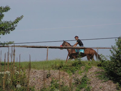
I read about the park on-line after our visit. This is actually a county park that is in the process of being built. Budget cuts have slowed progress. It is supposed to have three soccer fields when it's finished. In this picture, you can see a fence that separates the park from the Saddlebrook East development. According to the county plans, the entrance to the park is supposed to be through the Saddlebrook East neighborhood.

In the brush at the edge of the parking lot, we found an old sign that directed horse racing fans back to Washington and Baltimore.


And two nice soccer fields.

There is also a short trail that runs along the soccer fields.

The race track sits on a hill above the parking lot. We occasionally caught a glimpse of a horse and rider.

I read about the park on-line after our visit. This is actually a county park that is in the process of being built. Budget cuts have slowed progress. It is supposed to have three soccer fields when it's finished. In this picture, you can see a fence that separates the park from the Saddlebrook East development. According to the county plans, the entrance to the park is supposed to be through the Saddlebrook East neighborhood.

In the brush at the edge of the parking lot, we found an old sign that directed horse racing fans back to Washington and Baltimore.

I'll post more on other parks we explored in future posts.
Subscribe to:
Posts (Atom)
